Overview
Contents
Overview
Purpose
The observational data products geometry metadata available within the ESA’s Planetary Science Archive (PSA) datasets are typically computed and provided by the instrument teams. However, the level of completeness and consistency of these metadata may vary considerably across instruments and missions.
In order to enable PSA end-users with searching capabilities for all observational data products based on geometrical parameters in a consistent way, and to offer rich map-based visualisation and features, a common and independent approach and tool - GEOGEN - has been developped for computing observational geometry metadata.
Function
GEOGEN is a SPICE-based command line interface (CLI) to compute PDS observational data products geometry metadata for ingestion into the ESA’s Planetary Science Archive (PSA).
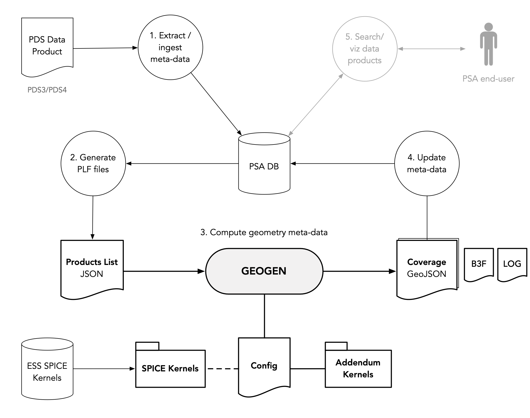
The following figure illustrates the PSA geometry generation end-to-end system and process using GEOGEN: from the PDS datasets ingestion process, to the generation of observational geometry metadata, to the end-users geometrical search and PSA UI interactions.
GEOGEN takes as input a Products List File (PLF) containing a list of PDS data products properties, and generates one or several output Coverage GeoJSON files containing the geometry metadata associated to each valid input observational data product. B3F files are also generated.
Observation geometry meta consists of a footprint and a set of 55 geometry parameters that are intended to cover the interest of as many scientific disciplines as possible, and be relevant to all detector types.
- Product List File (PLF)
A minimum set of data product properties is required for GEOGEN to derive the SPICE detector geometry model and observational parameters applicable to a given data product, and to compute the associated observation geometry metadata.
- Coverage GeoJSON file
Output geometry metadata are generated in the standard GeoJSON format to ease the ingestion process into the PSA GIS system. Observational products within a coverage are grouped by target, mission, instrument, product type, target surface model (ellipsoidal or digital shape model), and whether or not footprints crossing the target body antimeridian are split.
- Configuration
The computation of the input data products geometry metadata is done according to a user-defined configuration file, which allows for the definition of “computation-enabled” targets, instrument hosts, instruments, and product types; defining the required data product properties for a given instrument data product type. It links to applicable ESA’s SPICE Kernels and to addendum kernels used to define supplementary information required to interpret the applicable detector geometry model.

